Benutzer:Shi Annan/Skorta
Wenn du dies liest:
|
Wenn du diesen Artikel überarbeitest:
|

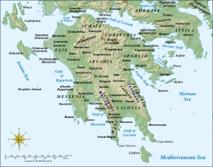
Skorta (griechisch τὰ Σκορτὰ, französisch Escorta) war der Name eines Historisches Territorium|Historisches Territorium, der im 13. und 14. Jahrhundert in Gebrauch war, during the period of Frankish rule in the Peloponnese, to designate the mountainous western half of the region of Arkadien, which separated the coastal plains of the western (Elisian) and southwestern (Messinian) Peloponnese from the Arcadian plateau in the interior.[1] The name is found chiefly in the various-language editions of the Chronik von Morea. It also appears as Skodra and Skorda (Σκορδὰ, Σκοδρὰ), in the Chronik des Pseudo-Dorotheos von Monemvasia.[2]
The northern portion of this area, around Akova, was also known by the Greek name Mesarea (Μεσαρέα, a common term in Greece for inland locations, cf. Mesaria[3]); in some cases, when juxtaposed with Mesarea, the term "Skorta" is limited to the southern portion, around Karytaina.[4] The local population was renowned for its rebellious character, and never fully submitted to the Frankish Princes of Achaea. It frequently rose up, aided by the Byzantine Greeks of the province of Mystras. As a result, two of the most powerful baronies of Achaea were set up to control the region, the Barony of Akova in the north and the Barony of Karytaina (or Skorta) in the south.[5]
The region of Skorta rose up in rebellion ca. 1302, when Prince Philip of Savoy raised new taxes on the local Greek gentry. Taking advantage of the absence of the Principality's marshal, Nicholas III of Saint Omer, with many troops on campaign in Thessaly, and with the aid of the Byzantines of Mystras, the rebels took and burned to the ground the castles of Saint Helen and of Crèvecoeur, and laid siege to the castle of Beaufort. When the Prince with the levies from his feudatories moved against the Greeks, however, the latter chose to withdraw, and Frankish rule was swiftly re-established over the region.[6]
Einzelnachweise
Literatur
- Bon|first=Antoine|title=La Morée Franque: Recherches Historiques, Topographiques et Archéologiques sur la Principauté d’Achaïe |year=1969|language=French|location=Paris|publisher=De Boccard|url=http://cefael.efa.gr/detail.php?site_id=1&actionID=page&serie_id=BefarA&volume_number=213&issue_number=1
- The Frankish States in Greece, 1204–1311 | pages = 234–275 | last = Longnon | first = Jean |title=A History of the Crusades, Volume II: The Later Crusades, 1189–1311 | editor1-first= Robert Lee | editor1-last=Wolff | editor2-first=Harry W. | editor2-last=Hazard |year=1969 |publisher=University of Wisconsin Press | chapterurl=http://digicoll.library.wisc.edu/cgi-bin/History/History-idx?type=article&did=History.CrusTwo.i0021&id=History.CrusTwo ISBN 0-299-06670-3
[[Kategorie:Historisches Territorium]]Category:Medieval Arcadia]] [[Category:Historical regions in Greece]]