Datei:CO 1069-137-83.jpg
CO_1069-137-83.jpg (457 × 293 Pixel, Dateigröße: 77 KB, MIME-Typ: image/jpeg)
![]()
Diese Datei und die Informationen unter dem roten Trennstrich werden aus dem zentralen Medienarchiv Wikimedia Commons eingebunden.
Beschreibung
| BeschreibungCO 1069-137-83.jpg |
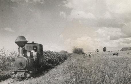
English: Nyanza Province. Sugar-Cane fields at Miwani, near the Port of Kisumu. About half the sugar in the Colony is grown here and one big company has over 9,000 acres under cultivation.
Location: Nyanza Province, Kenya Our Catalogue Reference: Part of CO 1069/137 This image is part of the Colonial Office photographic collection held at The National Archives, uploaded as part of the Africa Through a Lens project. Feel free to share it within the spirit of the Commons. Our records about many of these images are limited. If you have more information about the people, places or events shown in an image, please use the comments section below. We have attempted to provide place information for the images automatically but our software may not have found the correct location. Alternatively you could use the Suggestify tool to suggest the location of a picture. For high quality reproductions of any item from our collection please contact our image library |
| Datum | |
| Quelle | https://www.flickr.com/photos/nationalarchives/5405043104/ |
| Urheber | The National Archives UK |
| Andere Versionen |
 |
| Kameraposition | 0° 30′ 00″ S, 34° 30′ 00″ O | Dieses und weitere Bilder auf OpenStreetMap |
|---|
Lizenz
Dieses Bild wurde von Flickrs The Commons übernommen. Die hochladende Organisation kann verschiedene Gründe für die Feststellung haben, dass keine bekannten Urheberrechtsbeschränkungen bestehen, wie z. B.: No known copyright restrictionsNo restrictionshttps://www.flickr.com/commons/usage/false
Weitere Informationen findest du unter https://flickr.com/commons/usage/. Bitte füge zusätzliche Lizenzvorlagen zu diesem Bild hinzu, wenn genauere Informationen zum Urheberrechts-Status ermittelt werden können. Siehe Commons:Licensing für weitere Informationen. |
| Diese Bilddatei wurde ursprünglich auf Flickr durch The National Archives UK in https://flickr.com/photos/31575009@N05/5405043104 hochgeladen. Sie wurde am 28. Januar 2021 durch den FlickreviewR 2-Bot geprüft und die Lizenzierung der Datei unter den Bedingungen von No known copyright restrictions wurde bestätigt. |
28. Januar 2021
Kurzbeschreibungen
In dieser Datei abgebildete Objekte
Motiv
Einige Werte ohne einen Wikidata-Eintrag
31. Januar 2011
0°30'S, 34°30'E
image/jpeg
0e03f9496cc957aaee6fe132741226cf8da90fef
79.339 Byte
293 Pixel
457 Pixel
Dateiversionen
Klicke auf einen Zeitpunkt, um diese Version zu laden.
| Version vom | Vorschaubild | Maße | Benutzer | Kommentar | |
|---|---|---|---|---|---|
| aktuell | 08:37, 17. Okt. 2021 |  | 457 × 293 (77 KB) | wikimediacommons>NearEMPTiness | Cropped 54 % horizontally, 58 % vertically, rotated -0.7° using CropTool with precise mode. |
Dateiverwendung
Die folgende Seite verwendet diese Datei:
Metadaten
Diese Datei enthält weitere Informationen (beispielsweise Exif-Metadaten), die in der Regel von der Digitalkamera oder dem verwendeten Scanner stammen. Durch nachträgliche Bearbeitung der Originaldatei können einige Details verändert worden sein.
| Bildtitel | <b>Description:</b> Nyanza Province. Sugar-Cane fields at Miwani, near the Port of Kisumu. About half the sugar in the Colony is grown here and one big company has over 9,000 acres under cultivation.
<b>Location:</b> Nyanza Province, Kenya <b>Our Catalogue Reference:</b> Part of CO 1069/137 This image is part of the Colonial Office photographic collection held at The National Archives, uploaded as part of the Africa Through a Lens project. Feel free to share it within the spirit of the Commons. Our records about many of these images are limited. If you have more information about the people, places or events shown in an image, please use the comments section below. We have attempted to provide place information for the images automatically but our software may not have found the correct location. Alternatively you could use the <a href='http://suggestify.appspot.com/'>Suggestify</a> tool to suggest the location of a picture. For high quality reproductions of any item from our collection please contact our <a href='http://www.nationalarchives.gov.uk/imagelibrary' rel='nofollow'>image library</a> |
|---|---|
| Geografische Breite | 0° 30′ 0″ S |
| Geografische Länge | 34° 30′ 0″ E |
| Horizontale Auflösung | 150 dpi |
| Vertikale Auflösung | 150 dpi |
| Y und C Positionierung | Zentriert |
| Exif-Version | 2.3 |
| Bedeutung einzelner Komponenten |
|
| unterstützte Flashpix-Version | 1 |
| Farbraum | Nicht kalibriert |
| Bild-ID | CO 1069/137,{83} |
| GPS-Tag-Version | 2.3.0.0 |
