Datei:Goa-Vasco 03-2016 12 Dabolim Airport.jpg
Originaldatei (5.223 × 2.938 Pixel, Dateigröße: 5,42 MB, MIME-Typ: image/jpeg)
Diese Datei und die Informationen unter dem roten Trennstrich werden aus dem zentralen Medienarchiv Wikimedia Commons eingebunden.
BeschreibungGoa-Vasco 03-2016 12 Dabolim Airport.jpg |
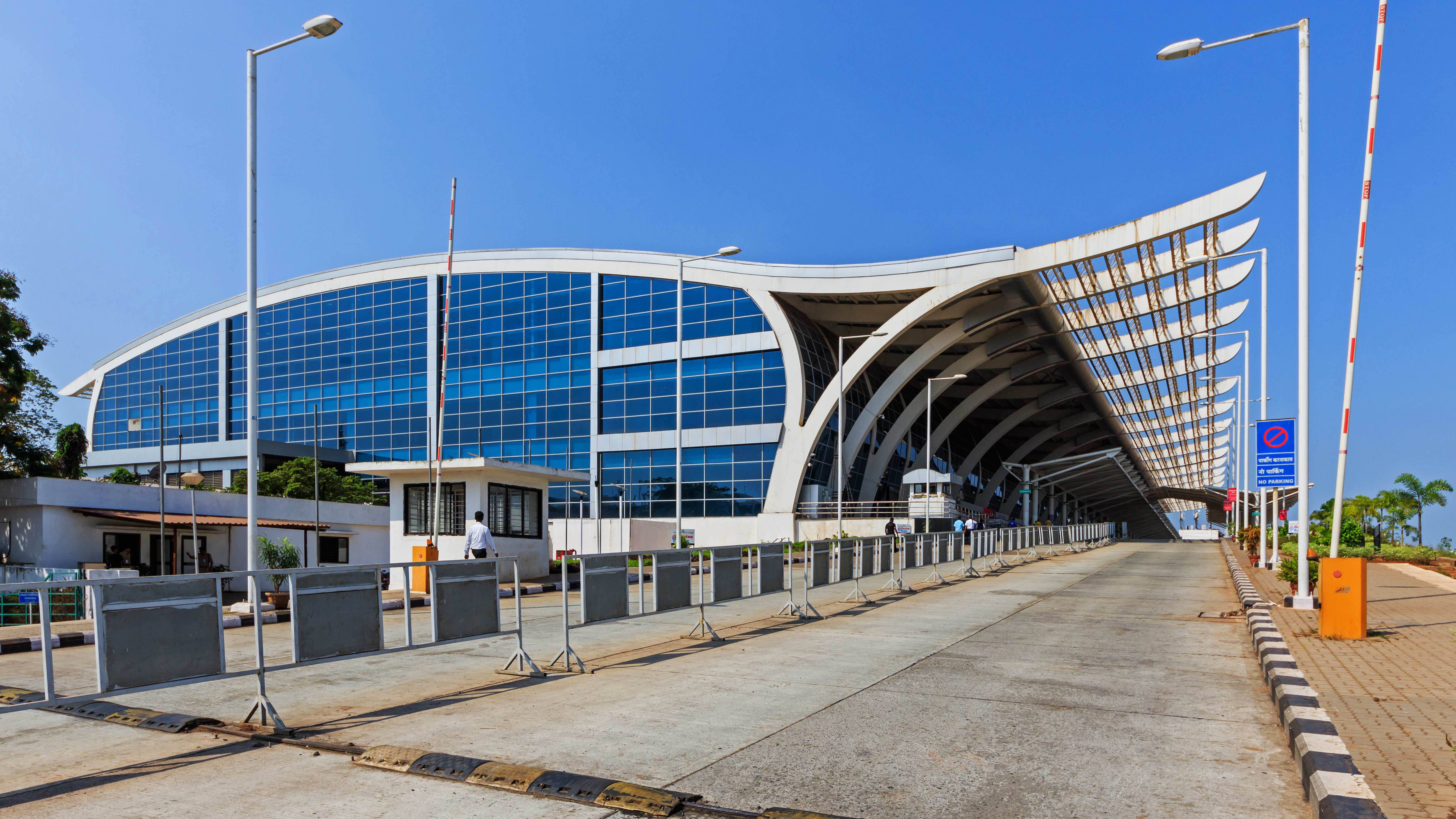
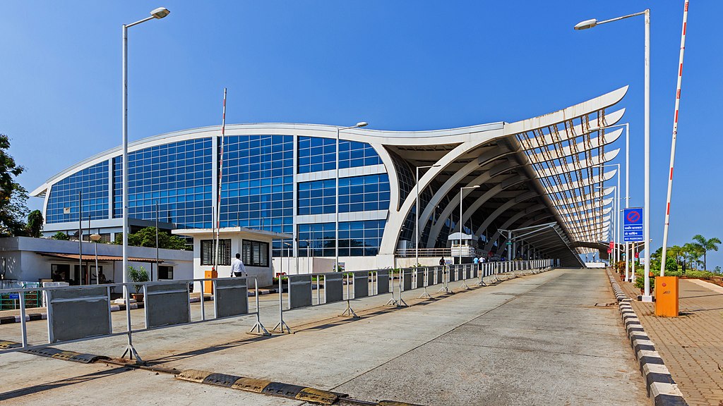
English: The Goa International Airport (aka Dabolim Airport) in Vasco da Gama (Goa), India
Русский: Терминал международного аэропорта Даболим в Васко-да-Гама (Гоа), Индия |
||
Datum | |||
Quelle | Eigenes Werk | ||
Urheber | A.Savin | ||
Genehmigung (Weiternutzung dieser Datei) |
Free Art License. Free usage of the photo; usually no need to ask for approval.
Just attribute the author: «A.Savin, Wikipedia»; if you have questions — Telegram , or e-mail to wikiphotospace@gmail.com .Лицензия Свободное искусство. Использование фотографии бесплатно; согласование обычно не требуется. Просто укажите в качестве автора: «А.Савин, Википедия»; если есть вопрос — телеграм , или эл.почта на wikiphotospace@gmail.com .Lizenz Freie Kunst. Nutzung des Fotos kostenlos; Anfrage in der Regel nicht erforderlich. Kennzeichnen Sie einfach als Autor: «A.Savin, Wikipedia»; falls Sie Fragen haben — Telegram , oder E-Mail an wikiphotospace@gmail.com .
Thank you.
|
Kameraposition | 15° 23′ 08,6″ N, 73° 50′ 25,1″ O | Dieses und weitere Bilder auf OpenStreetMap | 15.385722; 73.840306 |
---|
Dieses Bild wurde unter Berücksichtigung der Leitlinie für Qualitätsbilder bewertet und gilt als Qualitätsbild.
العربية ∙ جازايرية ∙ беларуская ∙ беларуская (тарашкевіца) ∙ български ∙ বাংলা ∙ català ∙ čeština ∙ Cymraeg ∙ Deutsch ∙ Schweizer Hochdeutsch ∙ Zazaki ∙ Ελληνικά ∙ English ∙ Esperanto ∙ español ∙ eesti ∙ euskara ∙ فارسی ∙ suomi ∙ français ∙ galego ∙ עברית ∙ हिन्दी ∙ hrvatski ∙ magyar ∙ հայերեն ∙ Bahasa Indonesia ∙ italiano ∙ 日本語 ∙ Jawa ∙ ქართული ∙ 한국어 ∙ kurdî ∙ Lëtzebuergesch ∙ lietuvių ∙ македонски ∙ മലയാളം ∙ मराठी ∙ Bahasa Melayu ∙ Nederlands ∙ Norfuk / Pitkern ∙ polski ∙ português ∙ português do Brasil ∙ rumantsch ∙ română ∙ русский ∙ sicilianu ∙ slovenčina ∙ slovenščina ∙ shqip ∙ српски / srpski ∙ svenska ∙ தமிழ் ∙ తెలుగు ∙ ไทย ∙ Tagalog ∙ toki pona ∙ Türkçe ∙ українська ∙ vèneto ∙ Tiếng Việt ∙ 中文 ∙ 中文(简体) ∙ 中文(繁體) ∙ +/− |
Das Bild wurde in der bengalischen Wikipedia zum Bild des Tages gewählt.
|
Lizenz
Copyleft: Dieses Kunstwerk ist frei, es darf weitergegeben und/oder modifiziert werden entsprechend den Bedingungen der Lizenz „Freie Kunst“.
Der vollständige Text der Lizenz steht auf der „Copyleft Attitude“-Seite sowie auf anderen Webseiten. http://artlibre.org/licence/lal/enFALFree Art Licensefalsetrue |
In dieser Datei abgebildete Objekte
Motiv
Einige Werte ohne einen Wikidata-Eintrag
15°23'8.599"N, 73°50'25.102"E
100
0,0025 Sekunde
13 Millimeter
Dateiversionen
Klicke auf einen Zeitpunkt, um diese Version zu laden.
Version vom | Vorschaubild | Maße | Benutzer | Kommentar | |
---|---|---|---|---|---|
aktuell | 17:05, 21. Apr. 2016 | 5.223 × 2.938 (5,42 MB) | wikimediacommons>A.Savin | {{User:A.Savin/F |Description= {{en|The Goa International Airport (aka Dabolim Airport) in Vasco da Gama (Goa), India}} {{ru|Терминал международного аэропорта Даболим в Васко-да-Гама (Гоа), Инди... |
Dateiverwendung
Die folgende Seite verwendet diese Datei:
Metadaten
Diese Datei enthält weitere Informationen (beispielsweise Exif-Metadaten), die in der Regel von der Digitalkamera oder dem verwendeten Scanner stammen. Durch nachträgliche Bearbeitung der Originaldatei können einige Details verändert worden sein.
Hersteller | Canon |
---|---|
Modell | Canon EOS 7D Mark II |
Fotograf | A.Savin |
Urheberrechte |
|
Belichtungsdauer | 1/400 Sekunden (0,0025) |
Blende | f/9 |
Film- oder Sensorempfindlichkeit (ISO) | 100 |
Erfassungszeitpunkt | 10:27, 17. Mär. 2016 |
Brennweite | 13 mm |
Geografische Breite | 15° 23′ 9,09″ N |
Geografische Länge | 73° 50′ 19,1″ E |
Höhe | 32,7 Meter über dem Meeresspiegel |
Breite | 5.472 px |
Höhe | 3.648 px |
Bits pro Farbkomponente |
|
Pixelzusammensetzung | RGB |
Kameraausrichtung | Normal |
Anzahl Komponenten | 3 |
Horizontale Auflösung | 300 dpi |
Vertikale Auflösung | 300 dpi |
Software | Adobe Photoshop CC (Windows) |
Speicherzeitpunkt | 16:42, 21. Apr. 2016 |
Belichtungsprogramm | Manuell |
Exif-Version | 2.3 |
Digitalisierungszeitpunkt | 10:27, 17. Mär. 2016 |
APEX-Belichtungszeitwert | 8,643856 |
APEX-Blendenwert | 6,33985 |
Belichtungsvorgabe | 0 |
Größte Blende | 4,75 APEX (f/5,19) |
Messverfahren | Muster |
Blitz | kein Blitz, Blitz abgeschaltet |
Erfassungszeitpunkt (1/100 s) | 00 |
Digitalisierungszeitpunkt (1/100 s) | 00 |
Farbraum | sRGB |
Sensorauflösung horizontal | 6.086,7630700779 |
Sensorauflösung vertikal | 6.090,1502504174 |
Einheit der Sensorauflösung | Zoll |
Benutzerdefinierte Bildverarbeitung | Standard |
Belichtungsmodus | Manuelle Belichtung |
Weißabgleich | Automatisch |
Aufnahmeart | Standard |
GPS-Zeit | 04:57:11.909 |
Für die Messung benutzte Satelliten | 23 |
Empfängerstatus | Messung läuft |
Messverfahren | 3-dimensionale Messung |
Messgenauigkeit | Gut (2) |
Geodätisches Referenzsystem | WGS-84 |
GPS-Datum | 17. März 2016 |
GPS-Tag-Version | 0.0.3.2 |
Seriennummer der Kamera | 033021000431 |
Verwendetes Objektiv | 8-16mm |
Datum zu dem die Metadaten letztmalig geändert wurden | 18:42, 21. Apr. 2016 |
Eindeutige Kennung des ursprünglichen Dokuments | 96DB02C16F0F927BD71074A2DD71CC93 |
IIM-Version | 4 |