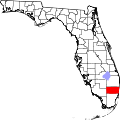
Datei:Map of Florida highlighting Broward County.svg
aus Wikipedia, der freien Enzyklopädie

Größe der PNG-Vorschau dieser SVG-Datei: 602 × 600 Pixel. Weitere Auflösungen: 241 × 240 Pixel | 482 × 480 Pixel | 771 × 768 Pixel | 1.028 × 1.024 Pixel | 2.055 × 2.048 Pixel | 1.130 × 1.126 Pixel.
Originaldatei (SVG-Datei, Basisgröße: 1.130 × 1.126 Pixel, Dateigröße: 179 KB)
Dateiversionen
Klicke auf einen Zeitpunkt, um diese Version zu laden.
| Version vom | Vorschaubild | Maße | Benutzer | Kommentar | |
|---|---|---|---|---|---|
| aktuell | 00:09, 5. Jul. 2024 |  | 1.130 × 1.126 (179 KB) | wikimediacommons>Nux | fix rendering (remove clipping), uniform colors |
Dateiverwendung
Die folgenden 39 Seiten verwenden diese Datei:
- Boulevard Gardens
- Broadview Park
- Broward County
- Coconut Creek
- Cooper City
- Coral Springs
- Dania Beach
- Davie
- Deerfield Beach
- Fort Lauderdale
- Franklin Park (Florida)
- Hallandale Beach
- Hillsboro Beach
- Hillsboro Pines
- Hollywood (Florida)
- Lauderdale-by-the-Sea
- Lauderdale Lakes
- Lauderhill
- Lazy Lake
- Lighthouse Point
- Margate (Florida)
- Miramar (Florida)
- North Lauderdale
- Oakland Park
- Parkland (Florida)
- Pembroke Park
- Pembroke Pines
- Plantation (Broward County, Florida)
- Pompano Beach
- Roosevelt Gardens
- Sea Ranch Lakes
- Southwest Ranches
- Sunrise (Florida)
- Tamarac
- Washington Park (Florida)
- West Park (Florida)
- Weston (Florida)
- Wilton Manors
- Vorlage:Navigationsleiste Orte im Broward County