Datei:Premongol.png
Premongol.png (752 × 590 Pixel, Dateigröße: 31 KB, MIME-Typ: image/png)
![]()
Diese Datei und die Informationen unter dem roten Trennstrich werden aus dem zentralen Medienarchiv Wikimedia Commons eingebunden.
Inhaltsverzeichnis
Beschreibung

|
This map has been uploaded by Electionworld from en.wikipedia.org to enable the |
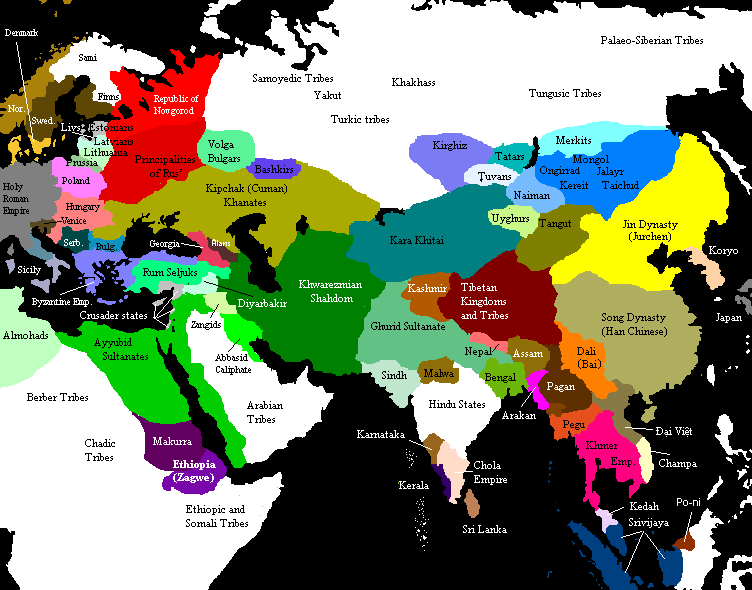
Eurasia on the eve of the Mongol invasions, c. 1200 CE. Source unknown. All of Central, North and East Asian states and tribes were located in wrong places.

|
Dieses Bild des Typs Historical map sollte als Vektorgrafik im SVG-Format neu erstellt werden. Vektorformate haben zahlreiche Vorteile; weitere Information unter Commons:Media for cleanup. Wenn dir eine SVG-Version dieses Bildes vorliegt, so lade diese bitte hoch. Nach dem Hochladen der Datei ist diese Vorlage auf der aktuellen Bildbeschreibungsseite durch die Vorlage {{Vector version available}}, oder kürzer {{Vva}}, zu ersetzen. Es ist empfohlen die neue SVG-Datei „Premongol.svg“ zu nennen – dann benötigt die Vorlage vector version available (bzw. vva) keinen Parameter.
|
Lizenz

|
Es ist erlaubt, die Datei unter den Bedingungen der GNU-Lizenz für freie Dokumentation, Version 1.2 oder einer späteren Version, veröffentlicht von der Free Software Foundation, zu kopieren, zu verbreiten und/oder zu modifizieren; es gibt keine unveränderlichen Abschnitte, keinen vorderen und keinen hinteren Umschlagtext.
Der vollständige Text der Lizenz ist im Kapitel GNU-Lizenz für freie Dokumentation verfügbar.http://www.gnu.org/copyleft/fdl.htmlGFDLGNU Free Documentation Licensetruetrue |
| Diese Datei ist unter der Creative-Commons-Lizenz „Namensnennung – Weitergabe unter gleichen Bedingungen 3.0 nicht portiert“ lizenziert. | ||
| ||
| Diese Lizenzmarkierung wurde auf Grund der GFDL-Lizenzaktualisierung hinzugefügt.http://creativecommons.org/licenses/by-sa/3.0/CC BY-SA 3.0Creative Commons Attribution-Share Alike 3.0truetrue |
See also

Original upload notes
20:43, 21 November 2006 . . Timmie.merc (talk | contribs | block) 752 × 590 (31,383 bytes) (Reverted to earlier revision)
20:42, 21 November 2006 . . Timmie.merc (talk | contribs | block) 752 × 590 (31,383 bytes) (Reverted to earlier revision)
17:31, 3 October 2006 . . Vilniškis (talk | contribs | block) 752 × 590 (31,383 bytes) (Eurasia on the eve of the Mongol invasions, c. 1200.)
17:26, 3 October 2006 . . Vilniškis (talk | contribs | block) 752 × 590 (31,383 bytes)
18:11, 26 September 2006 . . Nanshu (talk | contribs | block) 752 × 590 (20,501 bytes) (minor corrections on East Asia)
20:35, 6 June 2006 . . Foobaz (talk | contribs | block) 752 × 590 (20,505 bytes) (Changed name of Vietnam from Annam to Đại Việt as talk page suggested.)
12:26, 1 June 2006 . . Foobaz (talk | contribs | block) 752 × 590 (20,469 bytes) (fixed spelling error in Africa: "Berber Trubes" -> "Berber Tribes")
00:26, 14 January 2006 . . Briangotts (talk | contribs | block) 752 × 590 (45,292 bytes) (Eurasia on the eve of the Mongol invasions, c. 1200 CE. Category:Historical maps by User:Briangotts)
10:42, 22 December 2005 . . Briangotts (talk | contribs | block) 752 × 590 (44,927 bytes) (Eurasia on the eve of the Mongol invasions, c. 1200 CE. Category:Historical maps by User:Briangotts)
| Bildnotizen InfoField | Diese Datei ist annotiert: Betrachte diese auf Commons. |
Location of Valachia and Moldavian principalities which were not under any occupation or dominion at the time
Venice did not rule these territories before the 4th Crusade
Kurzbeschreibungen
In dieser Datei abgebildete Objekte
Motiv
Dateiversionen
Klicke auf einen Zeitpunkt, um diese Version zu laden.
| Version vom | Vorschaubild | Maße | Benutzer | Kommentar | |
|---|---|---|---|---|---|
| aktuell | 13:27, 29. Sep. 2019 |  | 752 × 590 (31 KB) | wikimediacommons>Бмхүн | incorrect{{DEFAULTSORT:<noinclude></noinclude>}} |
Dateiverwendung
Die folgenden 3 Seiten verwenden diese Datei:
