Datei:TorresStraitIslandsMap.png
aus Wikipedia, der freien Enzyklopädie

Größe dieser Vorschau: 604 × 599 Pixel. Weitere Auflösungen: 242 × 240 Pixel | 484 × 480 Pixel | 929 × 922 Pixel.
Originaldatei (929 × 922 Pixel, Dateigröße: 28 KB, MIME-Typ: image/png)
![]()
Diese Datei und die Informationen unter dem roten Trennstrich werden aus dem zentralen Medienarchiv Wikimedia Commons eingebunden.
![]()
Beschreibung

|
Dieses Bild des Typs Locator map sollte als Vektorgrafik im SVG-Format neu erstellt werden. Vektorformate haben zahlreiche Vorteile; weitere Information unter Commons:Media for cleanup. Wenn dir eine SVG-Version dieses Bildes vorliegt, so lade diese bitte hoch. Nach dem Hochladen der Datei ist diese Vorlage auf der aktuellen Bildbeschreibungsseite durch die Vorlage {{Vector version available}}, oder kürzer {{Vva}}, zu ersetzen. Es ist empfohlen die neue SVG-Datei „TorresStraitIslandsMap.svg“ zu nennen – dann benötigt die Vorlage vector version available (bzw. vva) keinen Parameter.
|
| Beschreibung |
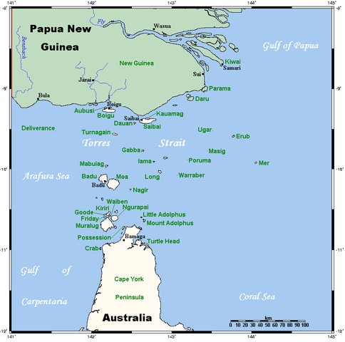
A map of the Torres Strait Islands. I have endeavoured to use native names wherever I could find them. If you can suggest ways in which this map could be made more up to date, don't hesitate to leave me a message to that effect. This map's source is here, with the uploader's modifications, and the GMT homepage says that the tools are released under the GNU General Public License. |
| Datum | 18. April 2006 (Original-Hochladedatum) |
| Quelle | Übertragen aus en.wikipedia nach Commons. |
| Urheber | Kelisi in der Wikipedia auf Englisch |
| Andere Versionen | Image:TorresStraitIslandsMap (zh).png |
Lizenz
Kelisi aus der englischsprachigen Wikipedia, der Nutzungsrechtsinhaber dieses Werkes, veröffentlicht es hiermit unter der folgenden Lizenz:
| Diese Datei ist unter der Creative-Commons-Lizenz „Namensnennung – Weitergabe unter gleichen Bedingungen 3.0 nicht portiert“ lizenziert. Vorbehaltlich der Haftungsausschlüsse. | ||
| Namensnennung: Kelisi aus der englischsprachigen Wikipedia | ||
| ||
| Diese Lizenzmarkierung wurde auf Grund der GFDL-Lizenzaktualisierung hinzugefügt. |

|
Es ist erlaubt, die Datei unter den Bedingungen der GNU-Lizenz für freie Dokumentation, Version 1.2 oder einer späteren Version, veröffentlicht von der Free Software Foundation, zu kopieren, zu verbreiten und/oder zu modifizieren; es gibt keine unveränderlichen Abschnitte, keinen vorderen und keinen hinteren Umschlagtext.
Der vollständige Text der Lizenz ist im Kapitel GNU-Lizenz für freie Dokumentation verfügbar. Vorbehaltlich der Haftungsausschlüsse. |
Ursprüngliches Datei-Logbuch
Die ursprüngliche Dateibeschreibungsseite war hier. Alle folgenden Benutzernamen beziehen sich auf en.wikipedia.
- 2006-04-19 00:55 Kelisi 929×922×8 (28510 bytes)
- 2006-04-18 03:38 Kelisi 929×922×8 (28133 bytes) A map of the Torres Strait Islands. I have endeavoured to use native names wherever I could find them. If you can suggest ways in which this map could be made more up to date, don't hesitate to leave me a message to that effect. This map's source is [htt
Dateiversionen
Klicke auf einen Zeitpunkt, um diese Version zu laden.
| Version vom | Vorschaubild | Maße | Benutzer | Kommentar | |
|---|---|---|---|---|---|
| aktuell | 06:42, 13. Jan. 2022 | | 929 × 922 (28 KB) | wikimediacommons>Kelisi | Reverted to version as of 00:09, 1 May 2007 (UTC) Hardly; those two colours are closer to each other. |
Dateiverwendung
Die folgenden 57 Seiten verwenden diese Datei:
- Albany Island
- Aureed Island
- Badu Island
- Bellevue-Inseln
- Bet Island
- Boigu
- Bourke-Inseln
- Bourke Island (Torres Strait)
- Bristow Island
- Coconut Island (Australien)
- Darnley Island
- Dauan
- Duncan-Inseln
- Entrance Island (Queensland)
- Farewell-Inseln
- Flagge der Torres-Strait-Insulaner
- Friday Island (Torres Strait)
- Gabba Island
- Goods Island
- Halfway Island (Torres Strait)
- Hammond Island
- Horn Island (Torres Strait)
- Kawai-Inseln
- Mabuiag
- Manar-Inseln
- Moa Island
- Murray-Inseln
- Murray Island
- Packe Island
- Poll Island
- Port Lihou Island
- Portlock Island
- Prince-of-Wales-Insel (Queensland)
- Red-Wallis-Inseln
- Saibai
- Sassie Island
- Stephens Island (Torres Strait)
- Sue Island
- Talbot-Inseln
- Tetley-Inseln
- The Three Sisters (Torres Strait)
- Thursday-Inseln
- Thursday Island
- Tobin Island
- Torres-Straits-Expedition
- Torres-Straße
- Trochus Island
- Tuesday-Inseln
- Turnagain Island
- Turtle Head Island
- Turtle Island (Torres Strait)
- Wednesday Island (Torres-Straße)
- Yam Island
- Yorke-Inseln
- Yorke Island
- Zagai
- Benutzer Diskussion:Ratzer/Archiv/2011

.png)