Upper River Region
| Karte | |
|---|---|
 Lage der Region in Gambia Lage der Region in Gambia
| |
 Upper River Region Upper River Region
| |
| Basisdaten | |
| Verwaltungsort | Basse Santa Su |
| Distrikte | 4 |
| Geographisches Zentrum | 13° 24′ N, 14° 11′ W |
| Nord-Süd-Ausdehnung | 40 km |
| Ost-West-Ausdehnung | 82 km |
| Fläche | 2.070 km² |
| Einwohnerzahl | 202.153 (Stand 2013) |
| Bevölkerungsdichte | 98 Einwohner/km² |
| ISO 3166-2 | GM-U
|
| Telefonvorwahl | (+220) 5 |
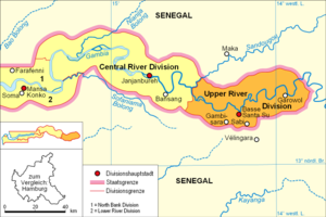
Die Upper River Region (vormals: Upper River Division) ist eine von sechs Verwaltungseinheiten des westafrikanischen Staates Gambia. Die Region entspricht der Local Government Area Basse.
Geographie
Die 2070 km² große Region, mit dem Sitz der Verwaltungseinheit in Basse Santa Su im Distrikt Fulladu East (11.859 Einwohner), ist weiter unterteilt in vier Distrikte. Mit 202.153 Einwohnern (Berechnung 2013)[1] ist es die östlichste Region und grenzt nur an die Central River Region.
Distrikte
Die vier Distrikte sind: Fulladu East, Kantora, Wuli, und Sandu.
Ortschaften
Die zehn größten Orte sind:
- Basse Santa Su, 11.859
- Sabi, 9987
- Gambissara, 9859
- Garowol, 8272
- Allunhari, 5784
- Demba Kunda, 5156
- Kularr, 4314
- Diabugu, 4196
- Koina, 4089
- Numuyel, 3994
Bevölkerung
Nach einer Erhebung von 1993[2] (damalige Volkszählung) stellt die größte Bevölkerungsgruppe die der Mandinka mit einem Anteil von rund drei Zehnteln, gefolgt von den Fula und den Wolof. Die Verteilung im Detail: 33,4 % Mandinka, 23,9 % Fula, 0,3 % Wolof, 0,2 % Jola, 40,5 % Serahule, 0,2 % Serer, 0 % Aku, 0,1 % Manjago, 0,7 % Bambara und 0,6 % andere Ethnien.
Geschichte
Ende 2007 wurde im Rahmen einer Verwaltungsreform aus der ehemaligen Upper River Division die Upper River Region.
|
<timeline>
ImageSize = width:400 height:320 PlotArea = left:50 bottom:20 width:350 height:300 TimeAxis = orientation:horizontal AlignBars = early Colors = id:hellgrau value:gray(0.9) id:graygrid value:gray(0.5) id:farbe value:blue DateFormat = yyyy Period = from:1961 till:2029 ScaleMajor = unit:year increment:10 start:1965
 bar:15 text:""


 bar:4 text:200000
 bar:3 text:150000
 bar:2 text:100000
 bar:1 text:50000
PlotData = color:hellgrau width:0.1 Bar:15 from:start till:end Bar:4 from:start till:end Bar:3 from:start till:end Bar:2 from:start till:end Bar:1 from:start till:end LineData = layer:front frompos:21 color:farbe width:1 at:1963 tillpos:90.6588 at:1973 tillpos:124.4004 at:1983 tillpos:154.6656 at:1993 tillpos:207.0708 at:2003 tillpos:240.6396 at:2005 tillpos:246.5664 at:2006 tillpos:249.4236 at:2007 tillpos:252.1956 at:2008 tillpos:254.6592 at:2009 tillpos:257.1432 at:2010 tillpos:259.5276 at:2012 tillpos:264.0552 at:2013 tillpos:263.5836 TextData = pos:(0,28) tabs:(46-right) text:"^0" pos:(0,320) tabs:(50-right) text:"^Einwohner" </timeline> |
Politik
Der Verwaltungseinheit steht ein Gouverneur vor, seit September 2013 ist Kanimang Sanneh Amtsinhaber dieser Position.
Einzelnachweise
- ↑ Upper River Region auf bevoelkerungsstatistik.de (online nicht mehr erreichbar, letzter Zugriff Mai 2013)
- ↑ Population by Ethnicity, by Settlement and Local Government Area. (Gambians Only) (Memento vom 13. November 2012 im Internet Archive) PDF-Datei