Distrikt Chocope
| Distrikt Chocope | ||
|---|---|---|
 Der Distrikt Chocope liegt zentral der Provinz Ascope (rot markiert) | ||
| Symbole | ||
| ||
| Basisdaten | ||
| Staat | Peru | |
| Region | La Libertad | |
| Provinz | Ascope | |
| Sitz | Chocope | |
| Fläche | 100,2 km² | |
| Einwohner | 9321 (2017) | |
| Dichte | 93 Einwohner pro km² | |
| ISO 3166-2 | PE-LAL | |
| Webauftritt | munichocope.gob.pe (spanisch) | |
| Politik | ||
| Alcalde Distrital | Carlos Alza Moncada (2019–2022) | |
| Partei | Alianza Popular Revolucionaria Americana | |
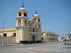
| Kirche und Karmeliterkonvent in Chocope | ||
Der Distrikt Chocope liegt in der Provinz Ascope in der Region La Libertad in Nordwest-Peru.
Geografie
Der Distrikt Chocope liegt zentral in der Provinz Ascope im Küstentiefland am Nordufer des Río Chicama. Der Fluss fließt entlang der südöstlichen Distriktgrenze nach Südwesten. Der Distrikt Chocope grenzt im Südwesten an den Distrikt Magdalena de Cao, im Westen an den Distrikt Paiján, im Norden an den Distrikt Casa Grande sowie im Osten an den Distrikt Chicama. Verwaltungssitz ist die 109 m hoch gelegene Stadt Chocope. Der Distrikt ist 100,24 km² groß.
Der Distrikt hatte 2017 beim Zensus 9321 Einwohner. Im Jahr 2007 lag die Einwohnerzahl bei 10.138. Es wird bewässerte Landwirtschaft betrieben.
Verkehr
Die Nationalstraße 1N (Panamericana) führt von Trujillo kommend an Chocope vorbei nach Norden.
Durch Chocope führte die in den 1870er Jahren eröffnete Bahnstrecke Puerto Salaverry–Ascope. Sie wurde 1967 stillgelegt.[1]
Weblinks
- Municipalidad Distrital de Chocope
- Peru: Region La Libertad (Provinzen und Bezirke) bei www.citypopulation.de
- INEI Perú
Einzelnachweise
- ↑ Robert D. Whetham: Railways of Peru. Volume 1: The Northern Lines. Trackside Publications, Skipton 2007. Ohne ISBN, S. 44f.

