La Groutte
aus Wikipedia, der freien Enzyklopädie
| La Groutte | ||
|---|---|---|
| Staat | Frankreich | |
| Region | Centre-Val de Loire | |
| Département (Nr.) | Cher (18) | |
| Arrondissement | Saint-Amand-Montrond | |
| Kanton | Saint-Amand-Montrond | |
| Gemeindeverband | Cœur de France | |
| Koordinaten | 46° 41′ N, 2° 31′ O | |
| Höhe | 154–208 m | |
| Fläche | 2,92 km² | |
| Einwohner | 124 (1. Januar 2019) | |
| Bevölkerungsdichte | 42 Einw./km² | |
| Postleitzahl | 18200 | |
| INSEE-Code | 18107 | |
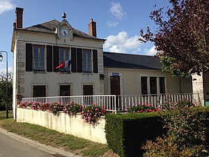
 Rathaus von La Groutte | ||
La Groutte ist eine französische Gemeinde mit 124 Einwohnern (Stand: 1. Januar 2019) im Département Cher in der Region Centre-Val de Loire; sie gehört zum Arrondissement Saint-Amand-Montrond und zum Kanton Saint-Amand-Montrond.
Geographie
La Groutte liegt etwa 50 Kilometer südsüdöstlich von Bourges. Der Cher begrenzt die Gemeinde im Norden und Osten. Umgeben wird La Groutte von den Nachbargemeinden Drevant im Norden und Osten, Ainay-le-Vieil im Süden und Südosten sowie Saint-Georges-de-Poisieux im Süden und Westen.
Bevölkerungsentwicklung
| 1962 | 1968 | 1975 | 1982 | 1990 | 1999 | 2006 | 2011 | 2018 |
|---|---|---|---|---|---|---|---|---|
| 163 | 137 | 97 | 89 | 104 | 103 | 118 | 129 | 126 |
| Quellen: Cassini und INSEE[1] | ||||||||
Sehenswürdigkeiten
- Oppidum von Les Murettes, neolithische Siedlung
Literatur
- Le Patrimoine des Communes du Cher. Flohic Editions, Band 2, Paris 2001, ISBN 2-84234-088-4, S. 733.
Einzelnachweise
Weblinks
Commons: La Groutte – Sammlung von Bildern, Videos und Audiodateien

