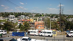
Municipio Nicolás Romero
| Nicolás Romero | |
|---|---|

| |
| Basisdaten | |
| Staat | Mexiko |
| Bundesstaat | México |
| Sitz | Villa Nicolás Romero |
| Fläche | 235,5 km² |
| Einwohner | 366.602 (2010) |
| Dichte | 1.556,7 Einwohner pro km² |
| Webauftritt | nicolasromero.gob.mx |
| INEGI-Nr. | 15060 |
| Politik | |
| Presidente municipal | Martín Sobreyra Peña |
| Villa Nicolás Romero | |
Koordinaten: 19° 38′ N, 99° 19′ W
Nicolás Romero ist ein Municipio im mexikanischen Bundesstaat México. Es gehört zur Zona Metropolitana del Valle de México, der Metropolregion um Mexiko-Stadt.
Das Municipio zählte beim Zensus 2010 366.602 Einwohner, seine Fläche beläuft sich auf 235,5 km². Verwaltungssitz und größte Ort des Municipios ist Villa Nicolás Romero.
Geographie
Nicolás Romero liegt zentral im Bundesstaat México, etwa 20 km nordöstlich von Mexiko-Stadt auf durchschnittlich 2370 m Höhe. Je etwa 40 % des Municipios sind landwirtschaftlich genutzt bzw. bewaldet.
Das Municipio Nicolás Romero grenzt an die Municipios Villa del Carbón, Tepotzotlán, Cuautitlán Izcalli, Atizapán de Zaragoza, Isidro Fabela, Temoaya und Jiquipilco.
Orte
Das Municipio Nicolás Romero umfasst 43 Orte, 13 von ihnen haben mehr als 2.500 Einwohner, 16 weitere zumindest 500 Einwohner. Die größten Orte sind:
| Ortsname | Bevölkerung (2010) |
|---|---|
| Villa Nicolás Romero | 281.799 |
| Veintidós de Febrero | 13.031 |
| Progreso Industrial | 11.289 |
| Quinto Barrio | 5.795 |
| Santa María Magdalena Cahuacán | 5.279 |
| San José el Vidrio | 5.204 |
| San Francisco Magú | 4.962 |
| San Miguel Hila | 4.373 |
Weblinks
- Enciclopedia de los Municipios y Delegaciones de México: Municipio Nicolás Romero (spanisch)
- INEGI: Datos Geográficos: Municipio Nicolás Romero (spanisch; PDF)

