Somita
| Somita | ||
|---|---|---|
| Koordinaten: 13° 12′ N, 16° 18′ W | ||
| Region: | West Coast | |
| Distrikt: | Foni Brefet | |
| Einwohner: | 2946 (2013)
| |
| <timeline>
ImageSize = width:240 height:140 PlotArea = left:50 bottom:20 width:190 height:120 TimeAxis = orientation:horizontal AlignBars = early Colors = id:hellgrau value:gray(0.9) id:graygrid value:gray(0.5) id:farbe value:drabgreen DateFormat = yyyy Period = from:1961 till:2028 ScaleMajor = unit:year increment:15 start:1965
 bar:15 text:""


 bar:4 text:4000
 bar:3 text:3000
 bar:2 text:2000
 bar:1 text:1000
PlotData = color:hellgrau width:0.1 Bar:15 from:start till:end Bar:4 from:start till:end Bar:3 from:start till:end Bar:2 from:start till:end Bar:1 from:start till:end LineData = layer:front frompos:21 color:farbe width:1 at:1993 tillpos:64.632 at:2006 tillpos:83.256 at:2007 tillpos:84.504 at:2008 tillpos:89.28 at:2009 tillpos:90.576 at:2010 tillpos:91.872 at:2012 tillpos:94.392 at:2013 tillpos:91.704 TextData = pos:(0,28) tabs:(46-right) text:"^0" pos:(0,140) tabs:(50-right) text:"^Einwohner" </timeline> | ||
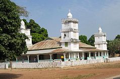
| Moschee in Somita | ||
Somita ist eine Ortschaft im westafrikanischen Staat Gambia.
Nach einer Berechnung für das Jahr 2013 leben dort etwa 2946 Einwohner, das Ergebnis der letzten veröffentlichten Volkszählung von 1993 betrug 1818.[1]
Geographie
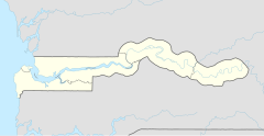
Somita, in der West Coast Region, Distrikt Foni Brefet, liegt ungefähr 43 Kilometer östlich von Brikama und ungefähr zwölf Kilometer westlich von Sibanor entfernt. Die Stadt liegt an der South Bank Road, Gambias wichtigster Fernstraße.
Kultur und Sehenswürdigkeiten
Bei Somita sind mehrere Kultstätten bekannt:[2]
- Dofeo Jalang: heiliger Baum
- Walijang: heilige Bäume
- Jalang Ndemban: heiliger Ameisenhügel
- Baren: historischer Baum
- Kaffurin: Baum für die Zirkumzision
Siehe auch
Einzelnachweise
- ↑ Somita auf bevoelkerungsstatistik.de (online nicht mehr erreichbar, letzter Zugriff Mai 2013)
- ↑ Allen Meagher (Hrsg.): Historic sites of The Gambia. Ada Dinkiralu (Mandinka), Bereb-I-Chosan (Wolof), Tarica Tawal (Fula), Nannin (Jola), Soninke Ada (Serehuli), I-Mofan Chosan (Serer). An official guide to the monuments and sites of The Gambia. National Council for the Arts and Culture, Banjul The Gambia 1998, ISBN 9983-80-011-014.

