Chenango County
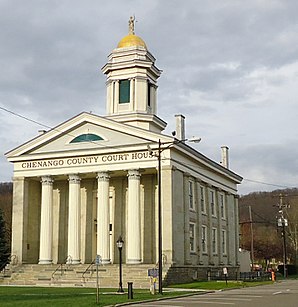
 Das Chenango County Courthouse (2011) liegt im gleichnamigen Historic District | |
| Verwaltung | |
|---|---|
| US-Bundesstaat: | New York |
| Verwaltungssitz: | Norwich |
| Gründung: | 15. März 1798 |
| Gebildet aus: | Tioga County |
| Vorwahl: | 001 607 |
| Demographie | |
| Einwohner: | (Stand: ) |
| Geographie | |
| Fläche gesamt: | 2327 km² |
| Wasserfläche: | 13,2 km² |
| Karte | |
| Website: www.co.chenango.ny.us | |
Chenango County[1] ist ein County im Bundesstaat New York der Vereinigten Staaten. Bei der Volkszählung im Jahr 2020 hatte das County 47.220 Einwohner und eine Bevölkerungsdichte von 20,4 Einwohnern pro Quadratkilometer.[2] Der Verwaltungssitz (County Seat) ist Norwich.
Geographie
Das County hat eine Fläche von 2.327,2 Quadratkilometern, wovon 13,2 Quadratkilometer Wasserfläche sind.
Umliegende Gebiete
| Cortland County | Madison County | Otsego County |
| Cortland County | 
|
Otsego County |
| Broome County | Broome County | Delaware County |
Geschichte
41 Bauwerke und Stätten des Countys sind im National Register of Historic Places eingetragen (Stand 18. Februar 2018).[3]
Einwohnerentwicklung
| Jahr | 1800 | 1810 | 1820 | 1830 | 1840 | 1850 | 1860 | 1870 | 1880 | 1890 |
|---|---|---|---|---|---|---|---|---|---|---|
| Einwohner | 15.666 | 21.704 | 31.215 | 37.238 | 40.785 | 40.311 | 40.934 | 40.564 | 39.891 | 37.776 |
| Jahr | 1900 | 1910 | 1920 | 1930 | 1940 | 1950 | 1960 | 1970 | 1980 | 1990 |
| Einwohner | 36.568 | 35.575 | 34.969 | 34.665 | 36.454 | 39.138 | 43.243 | 46.243 | 49.344 | 51.768 |
| Jahr | 2000 | 2010 | 2020 | 2030 | 2040 | 2050 | 2060 | 2070 | 2080 | 2090 |
| Einwohner | 51.401 | 50.477 | 47.220 |
Hinweis: Der Wert von 1810 ist lediglich aus der englischsprachigen Wikipedia ungeprüft übernommen worden, weil die Einwohnerzahlen für 1810 derzeit auf dem Server der Census-Behörde nicht verfügbar sind. (Stand: 22. Oktober 2020)
Städte und Ortschaften
Zusätzlich zu den unten angeführten selbständigen Gemeinden gibt es im Chenango County mehrere villages.
| Ortschaft | Status | Einwohner (2010)[5] |
Gesamte Fläche [km²] |
[6] Landfläche [km²] |
[6] Bevölkerungsdichte [Einwohner/km²] |
Gründung[7] | Besonderheit |
|---|---|---|---|---|---|---|---|
| Afton | town | 2.581 | 120,5 | 118,7 | 21,7 | 18. Nov. 1857 | |
| Bainbridge | town | 3.308 | 90,0 | 88,9 | 37,2 | 16. Feb. 1791 | Gründungsname „Jericho“; umbenannt am 15. April 1814 |
| Columbus | town | 975 | 97,1 | 96,8 | 10,1 | 11. Feb. 1805 | |
| Coventry | town | 1.655 | 126,6 | 126,1 | 13,1 | 7. Feb. 1806 | |
| German | town | 370 | 73,7 | 73,6 | 5,0 | 21. März 1806 | |
| Greene | town | 5.604 | 195,9 | 194,4 | 28,8 | 15. März 1798 | |
| Guilford | town | 2.922 | 160,5 | 159,8 | 18,3 | 3. Apr. 1813 | Gründungsname „Eastern“; umbenannt am 21. März 1817 |
| Lincklaen | town | 396 | 68,0 | 68,0 | 5,8 | 12. Apr. 1823 | |
| McDonough | town | 886 | 102,6 | 101,1 | 8,8 | 17. Apr. 1816 | |
| New Berlin | town | 2.682 | 120,6 | 119,5 | 22,4 | 3. Apr. 1807 | Name zwischen 9. Mai 1821 und 22. März 1822 „Lancaster“ |
| North Norwich | town | 1.783 | 73,2 | 72,9 | 24,5 | 7. Apr. 1849 | |
| Norwich City | city | 7.190 | 5,5 | 5,5 | 1.307,3 | 17. Apr. 1816 | Gründungsdatum als Village, zur City ernannt 1914 |
| Norwich Town | town | 3.998 | 108,9 | 108,7 | 36,8 | 19. Jan. 1793 | |
| Otselic | town | 1.054 | 98,5 | 98,4 | 10,7 | 28. März 1817 | |
| Oxford | town | 3.901 | 156,5 | 155,6 | 25,1 | 19. Jan. 1793 | |
| Pharsalia | town | 593 | 101,3 | 100,5 | 5,9 | 7. Apr. 1806 | Gründungsname „Stonington“; umbenannt am 6. April 1808 |
| Pitcher | town | 803 | 73,8 | 73,7 | 10,9 | 13. Feb. 1827 | |
| Plymouth | town | 1.804 | 109,7 | 109,2 | 16,5 | 7. Apr. 1806 | |
| Preston | town | 1.044 | 90,8 | 90,3 | 11,6 | 2. Apr. 1806 | |
| Sherburne | town | 4.048 | 112,9 | 112,8 | 35,9 | 5. März 1795 | |
| Smithville | town | 1.330 | 131,9 | 130,7 | 10,2 | 1. Apr. 1808 | |
| Smyrna | town | 1.280 | 109,2 | 109,0 | 11,7 | 25. März 1808 | Gründungsname „Stafford“; umbenannt am 6. April 1808 |
Literatur
- John Homer French: Gazetteer of the State of New York. R.P Smith, Syracuse NY 1860 (archive.org).
- Hiram C. Clark: History of Chenango county, containing the divisions of the county and sketches of the towns; Indian tribes and titles. Thompson & Pratt, Norwich NY 1850 (archive.org).
Weblinks
Einzelnachweise
- ↑ Chenango County im Geographic Names Information System des United States Geological Survey, abgerufen am 22. Oktober 2020.
- ↑ https://www.census.gov/quickfacts/fact/table/chenangocountynewyork/SBO030212
- ↑ Suchmaske Datenbank. In: National Register Information System. National Park Service, abgerufen am 18. Februar 2018.
- ↑ Einwohnerzahl 1800–2010 laut Volkszählungsergebnissen
- ↑ Einwohnerdaten aus dem US-Census von 2010. In: American Factfinder
- ↑ a b Offizielle Daten des United States Board on Geographic Names
- ↑ Franklin Benjamin Hough: Gazetteer of the State of New York. Band 1. A. Boyd, Albany NY 1873, S. 216 ff.
Koordinaten: 42° 29′ N, 75° 36′ W
