Broome County
aus Wikipedia, der freien Enzyklopädie
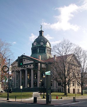
 Broome County Courthouse | |
| Verwaltung | |
|---|---|
| US-Bundesstaat: | New York |
| Verwaltungssitz: | Binghamton |
| Gründung: | 28. März 1806 |
| Gebildet aus: | Tioga County |
| Vorwahl: | 001 607 |
| Demographie | |
| Einwohner: | (Stand: ) |
| Geographie | |
| Fläche gesamt: | 1.853,1 km² |
| Wasserfläche: | 25,2 km² |
| Karte | |
| Website: www.gobroomecounty.com | |
Broome County[1] ist ein County im Bundesstaat New York der Vereinigten Staaten. Bei der Volkszählung im Jahr 2020 hatte das County 198.683 Einwohner und eine Bevölkerungsdichte von 108,7 Einwohnern pro Quadratkilometer.[2] Der Verwaltungssitz (County Seat) ist Binghamton.
Geographie
Das County hat eine Fläche von 1.853,1 Quadratkilometern, wovon 25,2 Quadratkilometer Wasserfläche sind.
Umliegende Gebiete
| Cortland County | Cortland County Chenango County |
Chenango County |
| Tioga County | 
|
Delaware County |
| Susquehanna County (PA) | Susquehanna County (PA) | Wayne County (PA) |
Geschichte
Ein Ort hat den Status einer National Historic Landmark, das New York State Inebriate Asylum.[3] 58 Bauwerke und Stätten des Countys sind insgesamt im National Register of Historic Places eingetragen (Stand 17. Februar 2018).[4]
Einwohnerentwicklung
| Jahr | 1800 | 1810 | 1820 | 1830 | 1840 | 1850 | 1860 | 1870 | 1880 | 1890 |
|---|---|---|---|---|---|---|---|---|---|---|
| Einwohner | – | 8130[Anm 1] | 14.343 | 17.579 | 22.338 | 30.660 | 35.906 | 44.103 | 49.483 | 62.973 |
| Jahr | 1900 | 1910 | 1920 | 1930 | 1940 | 1950 | 1960 | 1970 | 1980 | 1990 |
| Einwohner | 69.149 | 78.809 | 113.610 | 147.022 | 165.749 | 184.698 | 212.661 | 221.815 | 213.648 | 212.160 |
| Jahr | 2000 | 2010 | 2020 | 2030 | 2040 | 2050 | 2060 | 2070 | 2080 | 2090 |
| Einwohner | 200.536 | 200.600 | 198.683 |
Städte und Ortschaften
Zusätzlich zu den unten angeführten selbständigen Gemeinden gibt es im Broome County mehrere villages.
| Ortschaft | Status | Einwohner (2010)![6] Gesamte Fläche [km²]![7] Landfläche [km²]![7] Bevölkerungsdichte [Einwohner / km²] |
Gründung[8] | Besonderheit | |||
|---|---|---|---|---|---|---|---|
| Barker | town | 2.732 | 108,2 | 107,2 | 25,5 | 18. Apr. 1831 | |
| Binghamton City | city | 47.376 | 28,8 | 27,2 | 1741,8 | 9. Apr. 1867 | County Seat |
| Binghamton Town | town | 4.942 | 65,6 | 65,4 | 75,6 | 3. Dez. 1855 | |
| Chenango | town | 11.252 | 88,8 | 87,6 | 128,4 | 16. Feb. 1791 | |
| Colesville | town | 5.232 | 205,1 | 202,9 | 25,8 | 2. Apr. 1821 | |
| Conklin | town | 5.441 | 64,5 | 63,2 | 86,1 | 29. März 1824 | |
| Dickinson | town | 5.278 | 12,6 | 12,4 | 425,6 | 1890 | |
| Fenton | town | 6.674 | 89,0 | 84,9 | 78,6 | 3. Dez. 1855 | Gründungsname: Port Crane; Name geändert 26. März 1867 |
| Kirkwood | town | 5.857 | 80,8 | 79,8 | 73,4 | 23. Nov. 1859 | |
| Lisle | town | 2.751 | 121,7 | 121,5 | 22,6 | 7. Apr. 1801 | |
| Maine | town | 5.377 | 118,5 | 118,2 | 45,5 | 24. März 1847 | |
| Nanticoke | town | 1.672 | 63,1 | 62,9 | 26,6 | 18. Apr. 1831 | |
| Sanford | town | 2.407 | 235,7 | 233,4 | 10,3 | 2. Apr. 1821 | |
| Triangle | town | 2.946 | 103,0 | 98,1 | 30,0 | 18. Apr. 1831 | |
| Union | town | 56.346 | 93,2 | 91,8 | 613,8 | 16. Feb. 1791 | |
| Vestal | town | 28.043 | 136,2 | 134,0 | 209,3 | 22. Jan. 1823 | |
| Windsor | town | 6.274 | 240,9 | 237,6 | 26,4 | 27. März 1807 |
Literatur
- John Homer French: Gazetteer of the State of New York. R.P Smith, Syracuse NY 1860, S. 178 ff. (archive.org).
- Franklin Benjamin Hough: Gazetteer of the State of New York. Band 1. A. Boyd, Albany NY 1873, S. 174 ff. (archive.org).
Weblinks
Commons: Broome County – Sammlung von Bildern, Videos und Audiodateien
Anmerkungen
- ↑ Der Wert von 1810 ist lediglich aus der englischsprachigen Wikipedia ungeprüft übernommen worden, weil die Einwohnerzahlen für 1810 derzeit auf dem Server der Census-Behörde nicht verfügbar sind. (Stand: 1. November 2020)
Einzelnachweise
- ↑ Broome County (englisch) In: Geographic Names Information System. United States Geological Survey. Abgerufen am 22. Februar 2011.
- ↑ https://www.census.gov/quickfacts/fact/table/broomecountynewyork/SBO030212
- ↑ Listing of National Historic Landmarks by State: New York. (PDF) National Park Service; abgerufen am 18. Februar 2018.
- ↑ Suchmaske Datenbank im National Register Information System. National Park Service; abgerufen am 17. Februar 2018.
- ↑ Einwohnerzahl 1810–2010 laut Volkszählungsergebnissen
- ↑ Einwohnerdaten aus dem US-Census von 2010. In: American Factfinder
- ↑ a b Offizielle Daten. United States Board on Geographic Names
- ↑ Franklin Benjamin Hough: Gazetteer of the State of New York. Band 2. A. Boyd, Albany NY 1873, S. 176 ff.
Koordinaten: 42° 10′ N, 75° 50′ W

