La Bellière (Seine-Maritime)
aus Wikipedia, der freien Enzyklopädie
| La Bellière | ||
|---|---|---|
| Staat | Frankreich | |
| Region | Normandie | |
| Département (Nr.) | Seine-Maritime (76) | |
| Arrondissement | Dieppe | |
| Kanton | Gournay-en-Bray | |
| Gemeindeverband | 4 Rivières | |
| Koordinaten | 49° 36′ N, 1° 36′ O | |
| Höhe | 132–189 m | |
| Fläche | 4,54 km² | |
| Einwohner | 54 (1. Januar 2019) | |
| Bevölkerungsdichte | 12 Einw./km² | |
| Postleitzahl | 76440 | |
| INSEE-Code | 76074 | |
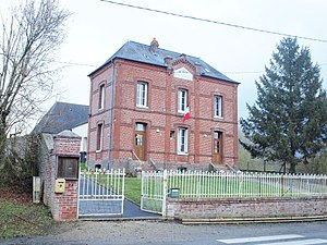
 Rathaus (Mairie) von La Bellière | ||
La Bellière ist eine französische Gemeinde mit 54 Einwohnern (Stand 1. Januar 2019) im Département Seine-Maritime in der Region Normandie. Sie gehört zum Arrondissement Dieppe und zum Kanton Gournay-en-Bray. Die Einwohner werden Bellois genannt.
Geographie
La Bellière liegt etwa 63 Kilometer südöstlich von Dieppe im Pays de Bray am Fluss Epte. Sie grenzt an Forges-les-Eaux, Longmesnil, Pommereux und Saumont-la-Poterie.
Bevölkerungsentwicklung
| Jahr | 1962 | 1968 | 1975 | 1982 | 1990 | 1999 | 2007 | 2014 |
| Einwohner | 92 | 90 | 62 | 75 | 54 | 71 | 59 | 55 |
Sehenswürdigkeiten
- Kirche Saint-Laurent
Weblinks
Commons: La Bellière – Sammlung von Bildern, Videos und Audiodateien
